QUICK ANSWER
There’s no single best USDA hardiness zone finder — the right one depends on what you actually need. The official USDA map gives you the most precise reading down to a specific address, tools like Old Farmer’s Almanac pair your zone with a frost-date window, The Infinite Harvest’s Zone Finder pairs it with frost probability, soil temperatures, and a soil-triggered planting calendar, and systems like the AHS Heat Zone Map or Sunset Western Garden Zones cover conditions the standard USDA bands don’t measure at all. Below are seven real options and what each one is actually good for.
USDA Plant Hardiness Zone Map · National Gardening Association ZipZone · Old Farmer’s Almanac · AHS Heat Zone Map · Sunset Western Garden Zones · Cooperative Extension Office · The Infinite Harvest Zone Finder
How These USDA Hardiness Zone Finder Tools Compare
They’re not all solving the same problem. A tool that gives you the most precise zone reading isn’t necessarily the most useful one if what you actually need is a frost date or a plant recommendation instead. Each entry below covers what the tool does, what it costs, and the one situation it’s genuinely best suited for.
| Tool | Type | Cost | Best For |
|---|---|---|---|
| USDA Plant Hardiness Zone Map | Interactive map | Free | Exact-address precision |
| NGA ZipZone Tool | ZIP lookup + plant database | Free | Zone + plant database in one step |
| Old Farmer’s Almanac | ZIP lookup + frost dates | Free | Almanac-aligned planting calendars |
| AHS Heat Zone Map | Reference map | Free | Heat stress, not cold |
| Sunset Western Garden Zones | Regional zone system | Free | Western U.S. microclimates |
| Cooperative Extension Office | Regional guidance + expert Q&A | Free | Hyperlocal accuracy |
| The Infinite Harvest Zone Finder | ZIP/postal lookup with zone, frost odds, soil temps & planting calendar | Free | Cited, all-in-one zone + planting-timing check, US & Canada |
USDA Plant Hardiness Zone Map (Official)
The interactive map at planthardiness.ars.usda.gov is the source everything else on this list points back to. It lets you zoom to street level and click a specific point to see your zone, sub-zone, and average annual minimum winter temperature, calculated from 1991–2020 data in 10°F bands split into 5°F half-zones. It’s free, with no account required.
• Best for: verifying your exact zone down to a specific address rather than a general ZIP-code area.
National Gardening Association ZipZone Tool
Garden.org’s zone lookup connects your zone directly to the organization’s own plant and seed-exchange database, so once you know your number you can browse plants by hardiness on the same site. Enter a ZIP code and you get your zone instantly.
• Best for: gardeners who want their zone lookup connected to a plant-database resource in the same step.
Old Farmer’s Almanac Hardiness Zone Tool
The Almanac pairs its zone lookup with a separate frost-date tool, so you can check both your winter cold tolerance and your planting window without leaving the site. It’s a long-established, broadly trusted gardening brand, which matters if you’re cross-referencing a zone number against other Almanac planting guidance you already use.
• Best for: gardeners who already follow Almanac planting calendars and want the zone lookup to match.
American Horticultural Society Heat Zone Map
This one measures something USDA zones don’t: heat stress, not cold tolerance. Developed by the American Horticultural Society in 1997 and still the standard reference, it rates regions on their number of annual “heat days” above 86°F — the threshold at which many plants begin losing cellular function. It’s complementary to a cold-hardiness zone finder, not a competitor to it.
• Best for: gardeners in hot-summer climates where heat damage, not winter cold, is the bigger risk to plant survival.
Sunset Western Garden Zones
For the western U.S., Sunset’s zone system accounts for factors USDA zones don’t capture: elevation, marine influence, rainfall timing, and length of growing season. Two spots with the same USDA zone can land in very different Sunset zones because of how those local conditions differ.
• Best for: gardeners in California, the Pacific Northwest, or the Mountain West who’ve found their USDA zone doesn’t quite match what actually survives in their yard.
Your State’s Cooperative Extension Office
Every U.S. state runs a land-grant university extension service, and most publish regional hardiness and planting guidance layered on top of the USDA map, accounting for local microclimates the broad USDA bands can’t. Many also offer a free “Ask Extension” service if your zone or planting-timing question needs a real person.
• Best for: hyperlocal accuracy, especially near zone boundaries or in regions with unusual microclimates.
The Infinite Harvest Zone Finder
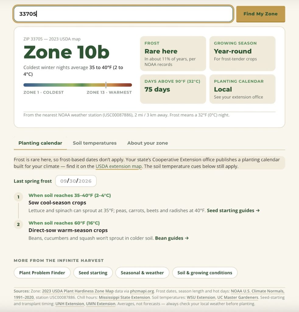
Our own tool goes further than a plain zone lookup. Enter a U.S. ZIP or Canadian postal code and it returns your USDA hardiness zone (on the full Zone 1–13 scale) along with your coldest-night temperature range, a realistic frost-risk read for your area, your growing season length, and your typical count of 90°F-plus days per year. For example, a St. Petersburg, FL ZIP code (33705) comes back as Zone 10b, with frost showing up in roughly 11% of years and a year-round growing season for frost-tender crops. No account or email required.
Results are organized into four tabs — About Your Zone, Soil Temperatures, Planting Calendar, and Full Planting Calendar — rather than one flat result. The planting calendar ties sowing windows to actual soil temperature, not just a date on a calendar: 40°F for peas, cabbage, carrots, beets, radishes, and turnips; 50°F for tomatoes and corn; and 60°F for beans, cucumbers, squash, peppers, eggplant, cantaloupe, watermelon, and pumpkin. It also draws the distinction extension offices use between an average last-frost date and a “safer” one — the date with only a 1-in-10 chance of frost, versus the 50/50 date most calendars quote. Every figure traces back to a cited source: the 2023 USDA Plant Hardiness Zone Map, NOAA’s 1991–2020 climate normals from the nearest weather station, WSU Extension for soil-temperature germination thresholds, UNH Extension for seed-to-transplant timing, and Natural Resources Canada for Canadian zones and postal-code lookups. From there it links straight into our symptom-based Plant Problem Finder for whatever comes up once things are in the ground.
• Best for: gardeners who want their zone, frost risk, soil temperature, and a soil-triggered planting calendar pulled from cited official sources in one place, for both U.S. and Canadian locations. Try the Zone Finder.
Related Questions
Is my USDA hardiness zone the same as my heat zone?
No. Your USDA zone measures winter cold tolerance based on average minimum temperatures. Heat zones, from the American Horticultural Society, measure something different: how many days per year get hot enough to stress plants. You can be in a cold winter zone and a high heat zone at the same time.
Why do two zone finder tools give me different answers?
Most of the difference comes down to data resolution. A tool using your ZIP code’s centroid can land you in a different half-zone than a tool that lets you click your exact address, especially near a zone boundary or at a different elevation than the rest of your ZIP code.
How often does the USDA hardiness zone map get updated?
The USDA updates the map periodically as 30-year climate averages shift; the current version uses 1991–2020 data. Check the official map periodically rather than relying on an old printed version, since zone boundaries can shift.